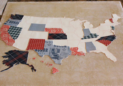
My map is 12" x 12". I did this because I wanted to use a 12" x 12" piece of cork behind the paper as backing. We plan on sticking pins in it to show where Dad (my husband) is traveling for work (he travels a fair amount, and I think it will be fun for the kids to track him).
 I also cut the large background US (seen here in white) with my Silhouette machine. It was also used to cut the state template pieces. However, I still cut the patterned paper states by hand.
The biggest difference is that I used My Mind's Eye's American Made paper. I think it's the perfect line for this patriotic project.


5 comments:
oh wow!!! that is a wonderful idea! how fun for the kids! :) and it looks amazing! :)
So cute! The papers really do make the project.
I also had to say that I am heading to A Walk Down Memory Lane tomorrow! I have never been and am taking a road trip from Sioux Falls (where I live). I am more than a little excited to shop at a GOOD stamp/scrap store!
:-)
Very, very nice. The boys are going to have so much fun putting marks were Dave is traveling.
I cannot tell you how much I adore this! Squeal! Thank you SO MUCH for sharing it.
Susan R. Opel
Creative Editor for Paper Crafts magazine
Wow, very nice! Can't wait to try this at home...
Post a Comment